Drone Topographic Survey
Transform your terrain analysis with our Drone Topographic Survey service, offering detailed aerial imagery for accurate topography mapping and terrain modelling.
Whether you're planning a construction project, conducting environmental research, or managing land resources, our professional drone survey service provides the high-resolution topographic data you need, enhancing planning precision and operational efficiency.
Our Process
Our service delivers an elevated perspective of your terrain, aiding in detailed topographic mapping, terrain analysis,
and resource management with unmatched precision and speed.
Initial Enquiry
We begin by engaging in a comprehensive discussion with the client to understand the specific requirements of the topographic survey. We explore the project area, the objectives of the survey, and the timeline, ensuring we capture every detail. This conversation is crucial for tailoring our services to your exact needs.
After gathering all the necessary information, we prepare a customised quote, offering you the flexibility to make an informed decision based on your specific requirements.


Shoot Day
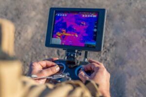
On the appointed day, our team, equipped with advanced drone technology, conducts a thorough survey of the terrain. Our drones, guided by experienced professionals, meticulously capture high-resolution images and videos, ensuring every contour and feature of the terrain is accurately documented. This process is not just about aerial photography; it's about gathering comprehensive data that offers a profound understanding of the terrain's characteristics.
The precision of our drones, combined with the expertise of our team, ensures that every nuance of the terrain is captured, providing a solid foundation for the subsequent analysis and decision-making stages.
Analysis & Evaluation
After the survey, our experts analyse the captured data, identifying key topographic features and terrain characteristics that align with your survey goals. We compile a comprehensive report, enriched with actionable insights, and provide you with the high-definition imagery and video footage from the survey.
This in-depth analysis equips our clients with the knowledge to make well-informed decisions, ensuring that planning, development, or conservation efforts are based on accurate, data-driven topographic insights.

drone topographic survey
FlyCamSolutions' Drone Topographic Survey service is meticulously designed to provide detailed and accurate terrain analysis. Ideal for engineers, architects, or environmentalists, our drones capture high-definition data, offering a clear and comprehensive view of the terrain's features.
This service provides an in-depth look at the terrain, facilitating precise topographic mapping, detailed terrain analysis, and efficient resource management with greater accuracy and less intrusion.
drone topographical surveys
Our drone topographic surveys surpass traditional surveying methods, offering a safer, more efficient, and non-intrusive alternative. By eliminating the need for physical presence on rugged or inaccessible terrain, we minimise safety risks and environmental impact.
Despite the non-invasive approach, our service ensures that you receive detailed and actionable topographic data, supporting responsible land use, project planning, and environmental conservation.

Ready to Elevate Your Surveying Experience?
Connect with the experts at Fly Cam Solutions today. Let us provide you with precise, efficient, and safe drone surveying solutions tailored to your needs.
BLOGS
Revolutionising Construction with Thermal Imaging Drones